
Geologic History of Devil’s Lake State Park
Let’s dig into the remarkable deep-time story behind the purple bluffs, the lake, and the landscape of one of Wisconsin’s most extraordinary places.
There is a moment, on the trail above the east shore of Devil’s Lake, when the scale of what you are looking at becomes difficult to hold in your mind. The maroon-purple rock of the bluff beside you formed when Earth was roughly half (HALF!) its current age. But the glacial ridge where you parked your car was only deposited approximately 15,000 years ago. The lake between them — so clear, so still on a calm morning — exists only because a glacier stalled here, dumped its debris, and dammed an ancient river on its way out of the region.
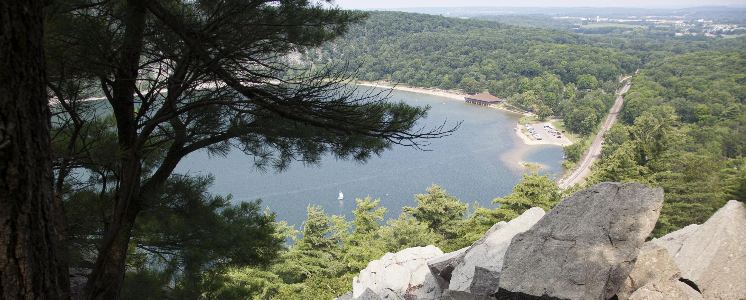
Looking northwest from atop the East Bluff. The North Shore Chateau sits on the shoreline, with railroad tracks leading north towards Baraboo in the distance.
These are not three separate stories. They are a single, continuous one. And Devil’s Lake State Park is one of the best places on Earth to read it.
This article walks through that story from beginning to present: how the rock (Baraboo quartzite) formed, what transformed it into one of the hardest materials on the planet, how the lake came to be, who the humans were who called this place sacred long before geologists arrived, and what the scientists who spent careers here ultimately contributed to the science of the Earth itself.
GEOLOGIC TIMELINE AT A GLANCE
~1.7 billion years ago Sand deposited in shallow seas along the edge of ancient Laurentia
~1.65 billion years ago Continental collision — Baraboo Quartzite born; Baraboo Syncline folds
~500 million years ago Tropical inland sea; quartzite bluffs stand as tropical islands
~250 million years ago Sea retreats; rivers strip overlying sediments, bluffs re-exposed
~15,000 years ago Wisconsin Glacier deposits moraines, dams the gorge, Devil’s Lake forms
700–1100 CE Ho-Chunk and Effigy Mound peoples construct ceremonial earthworks
Today You are standing beside some of the oldest exposed rock in southern Wisconsin
CHAPTER ONE
When Wisconsin Was a Beach
Our geologic story here begins roughly 1.7 billion years ago in the Precambrian period — the vast, mostly invisible portion of Earth’s history that accounts for about 88 percent of all geologic time. At that point, the land that would become Wisconsin sat near the equator, on the edge of a young continent called Laurentia, the ancient core of what is now North America. The climate was warm. The shoreline was shallow. And across this coastal margin, rivers were depositing enormous quantities of sand.
That sand accumulated in thick layers over millions of years, gradually compacting into a deep bed of sandstone. Even at this early stage, the sand recorded the world around it. Ripple marks formed by ancient current and wave action were pressed into the grains as they settled. Cross-bedded patterns left by migrating underwater dunes were preserved as the layers piled up.
These features — ripple marks, cross-beds, the fine grain of the sand itself — still survive today in the rock of the bluffs. They are among the oldest readable landscape records in this part of the country, frozen in stone for nearly two billion years.
👁️ LOOK FOR THIS
Ripple marks Look for wavy, parallel ridges on horizontal or gently sloped rock surfaces — most visible on flatter faces along the East Bluff Trail. They look almost identical to the patterns you see in sand at a modern beach. These particular ripples formed approximately 1.7 billion years ago.
Cross-bedding On some rock faces you’ll notice thin diagonal lines cutting through the stone at angles, like pages in a slightly tilted book. These are the preserved remnants of ancient sand dunes or underwater sand bars.
CHAPTER TWO
How Sandstone Becomes Quartzite — and Why It Matters
Sandstone is a common, relatively soft rock — porous, workable, and not particularly durable over geological timescales. If the Baraboo Hills were made of sandstone, they would have been worn flat long ago, like most of the surrounding Wisconsin farmland. The reason these bluffs still stand 500 feet above the valley floor, more than a billion years after they formed, is the sandstone was transformed into something far harder: quartzite.
About 1.65 billion years ago, the edge of another continent began to collide with Laurentia. The tectonic pressure was immense and prolonged, the kind that builds mountain ranges. That pressure drove the Baraboo sandstone deep underground, where it was subjected to extreme heat and compression over millions of years.
Under those conditions, the individual grains of sand (which in normal sandstone are merely cemented together by “mineral glue”) were instead fused directly to each other. Every grain of quartz bonded at the molecular level with its neighbors. The porous sandstone became a single, almost monolithic mass of interlocked crystals. That transformation — from sedimentary sandstone to metamorphic quartzite — is called metamorphism, and it is precisely what makes the rock here so different from anything else in the region.
“We geologists get light-headed when we touch it. It’s so ancient, like a relic from the past.”
— Paul Herr, UW-Extension Geologist
The result is one of the hardest rock types on Earth. A steel file barely scratches it. Most rock outcroppings elsewhere in this part of Wisconsin are sandstone or limestone — softer materials that erode quickly. The quartzite of the Baraboo Hills resisted that erosion for nearly two billion years, which is why it still forms ridges and bluffs while the surrounding landscape was worn away.
The iron and hematite (an iron oxide mineral) present in the original sand are responsible for the rock’s remarkable color. Pure quartzite is typically white or gray. The deep purple-to-maroon hues that define the bluffs at Devil’s Lake come from iron impurities distributed throughout the crystal matrix. That color isn’t a surface stain — it goes all the way through every stone.
👁️ LOOK FOR THIS
The purple color The distinctive maroon-to-purple hue of the bluffs is caused by iron (hematite) fused into the crystal structure of the quartzite itself (it’s not a surface stain or oxidation). If you break a fresh piece of loose talus, the color is uniform throughout.
The hardness Try scratching a quartzite boulder with your fingernail, a coin, or even a key. Nothing will mark it. The rock is harder than steel. That near-indestructibility is the reason the bluffs still stand after 1.7 billion years of erosion.
CHAPTER THREE
Mountains Higher than the Alps — Then Gone
The same tectonic collision that transformed the sandstone into quartzite also buckled the rock into massive folds. Picture a thick rug being pushed from two sides; it bows upward in the middle, forming ridges and valleys. The Baraboo Hills are the remnant of exactly this kind of folding event, which geologists call the Mazatzal Orogeny, a mountain-building episode that swept across the middle of the continent roughly 1.65 billion years ago.
The quartzite layers were compressed and bent into a shape geologists call a syncline — essentially a large U-shaped or bowl-shaped fold in the crust. The Baraboo Syncline is about 22 miles long and roughly 10 miles wide. Standing at the north shore of the lake and looking south across the water at the South Bluff, you are looking at one arm of that ancient U. The East Bluff is the other. The lake occupies a gap in the southern arm.
At their peak, these mountains may have rivaled the Alps or the Rockies in height. Then, over the next billion years, erosion did its patient work. Rain, rivers, wind, and freeze-thaw cycles stripped away the overlying rock layer by layer until only the most resistant material remained: the quartzite. What you see today is not a mountain range in the traditional sense. It is the deeply worn-down skeleton of mountains — the hardest parts, left standing after everything softer was carried away.
👁️ LOOK FOR THIS
The bowl shape from above A glance at any map or aerial view of the Baraboo Hills reveals their oval ring or “canoe”shape — North Range and South Range curving around a central valley. That oval is the outline of the Baraboo Syncline, the ancient fold in the crust, with its interior gradually worn away by erosion.
The Fold (North Shore) Near the north shore entrance to the park, a small but dramatic exposed fold shows layers of quartzite bent between layers of phyllite (a softer, shiny metamorphic rock). This is a compressed remnant of the mountain-building forces at work 1.65 billion years ago — geology made visible at human scale.
CHAPTER FOUR
Wisconsin Under a Tropical Sea
Jump forward about a billion years — to roughly 500 million years ago, in the Cambrian period. The ancient mountains had eroded dramatically. The quartzite ridges still stood, but they were smaller now, rising as islands from a warm, shallow inland sea that covered much of the continental interior. Wisconsin, carried northward by tectonic drift, sat near the equator. The climate was tropical. The water was warm and clear, teeming with some of the earliest animal life on Earth: trilobites, brachiopods, early worms — the beginnings of complex life in the sea.
These Baraboo Islands, as geologists sometimes call them, were battered by tropical storms. Waves crashed against the quartzite outcrops and flung boulders against one another with tremendous force. Percussion marks from those collisions — circular dings ground into the rock surface — survive to this day on some exposed faces of the bluff. You are, in effect, looking at wave damage from a storm that struck over 500 million years ago.
Over time, the sea deposited its own sediments — limestones, sandstones, and shales — on top of and around the quartzite ridges, eventually burying the bluffs entirely. For hundreds of millions of years, the quartzite lay hidden beneath a thick blanket of younger rock. Then, as the sea retreated and rivers returned, those softer overlying layers were stripped away — re-exposing the bluffs, over millions of years, roughly as we see them now.
👁️ LOOK FOR THIS
Percussion marks On the East Bluff Trail, look for rounded, bowl-shaped depressions on quartzite surfaces — especially on boulders and exposed faces near the upper trail. These were ground into the rock by boulders smashing against each other during ancient tropical storms, when the bluffs were island outcrops in a warm inland sea.
CHAPTER FIVE
How the Lake Got Here: A Glacier’s Unfinished Business
The lake itself is a recent feature by geologic standards — astonishingly young compared to the rock it sits between. To understand how it formed, you have to know what the landscape looked like before the last ice age.
About 15,000 years ago, the Wisconsin River flowed through the gap in the South Range that Devil’s Lake now occupies. The gorge was a river valley, carved over millions of years by flowing water. There was no lake — just a river working its way south through a notch in the quartzite ridges.
Then came the glacier. The Wisconsin Glacier — a massive lobe of the Laurentide Ice Sheet that once stretched from New York state to the Pacific Northwest — advanced from the northeast into this region. Thick enough to bury most of the landscape under hundreds of feet of ice, it nonetheless met its match in the quartzite ridges. The bluffs were too high and too hard to override. Instead, the glacier split, flowing around the eastern end of the Baraboo Hills while the western half of the range remained unglaciated.
As the glacier stalled and began to melt along the eastern margin of the hills, it deposited enormous piles of rock, gravel, sand, and debris — the accumulated freight it had been carrying south from Canada. These piles, called terminal moraines, were left like earthen plugs at both ends of the old river gorge: one at the north end of the lake, one at the south. The exits were sealed.
The river, its path blocked, was rerouted to the east. Water filled the sealed gorge. Devil’s Lake was born.
The Rock = 1.7B years old
Baraboo Quartzite — the oldest exposed rock in southern Wisconsin.
THE LAKE = ~15K years old
Devil’s Lake — formed when glacial moraines dammed an ancient river gorge.
👁️ LOOK FOR THIS
The moraines The gently rounded ridges at the north and south ends of the lake — where the parking lots, picnic areas, and concession buildings sit — are the terminal moraines: piles of debris deposited by the glacier as it stalled. The north moraine is about 80 feet thick; the southeast moraine is about 130 feet. Without them, there would be no lake.
The lake’s shape Devil’s Lake is rectangular — roughly a mile long and a half-mile wide — because it occupies a river gorge, not a basin scooped by glacial erosion. The straight, parallel bluffs on either side are the walls of that ancient river valley, still intact after millions of years.
The water itself The water in Devil’s Lake is not ancient glacial meltwater. That water cycled through Earth’s systems long ago. Today, the lake is fed by rainfall, groundwater springs, and a small stream entering from the southwest.
CHAPTER SIX
The Driftless Area: A Landscape That Escaped the Ice
Devil’s Lake sits at one of the most geologically curious edges in North America: the western boundary of the most recent glaciation. Just a few miles to the west of the park begins the Driftless Area — a region of southwestern Wisconsin, southeastern Minnesota, northeastern Iowa, and northwestern Illinois that, almost inexplicably, was never covered by glaciers during the most recent ice ages. This is true even though the surrounding landscape was overrun by ice multiple times over the past two million years.
The name “Driftless” comes from “drift” — the geological term for the debris deposited by glaciers. The Driftless Area has no drift. No moraines, no kettle lakes, no glacially rounded hills. Instead, it preserves a much older, more rugged landscape: deep river valleys carved over tens of millions of years, high sandstone bluffs, and soils never disturbed by ice.
The quartzite ridges of the Baraboo Hills appear to have played a role in deflecting and splitting the advancing ice sheet, helping to protect the western side of the range. The result is a park that straddles two entirely different worlds: the glacially sculpted terrain to the east, with its lake, moraines, and ice-deposited boulders, and the ancient, unglaciated terrain to the west, where the landscape has been shaped only by wind, water, and time.
👁️ LOOK FOR THIS
Standing on either bluff and looking west, you are looking at the Driftless Area — unglaciated terrain that has been slowly carved by rivers for tens of millions of years. Looking east and down at the lake, you are looking at a landscape shaped almost entirely by ice within the past 15,000 years. These two worlds meet at Devil’s Lake.
CHAPTER SEVEN
The Talus: A Hillside in Slow Motion
One of the park’s most visually striking features — the enormous, chaotic piles of boulders that cascade down the lower portions of all three bluffs — is itself a chapter in the geologic story. These talus slopes were produced during and after the last ice age through a process called freeze-thaw weathering.
Even quartzite, that nearly indestructible rock, is not entirely immune to the patient work of water. Water seeps into existing cracks and joints in the bluff face. When temperatures drop below freezing, the water expands by about nine percent as it turns to ice. Over hundreds of thousands of freeze-thaw cycles, this expansion slowly pries apart the rock, breaking off pieces ranging from gravel to multi-ton boulders. Those chunks tumble down the slope under gravity and accumulate at the base.
The talus at Devil’s Lake is still actively growing — slowly, but measurably. Some of the boulders in the talus field are enormous, larger than a car. Others are the size of a human head. The scramble trails through the talus offer a close-up view of quartzite in its most raw, unweathered form — fresh purple stone, still sharp-edged, still in the process of becoming part of the slope.
👁️ LOOK FOR THIS
Fresh vs. weathered talus On the talus slopes, compare the surfaces of boulders. Older, long-exposed stones are darkened by lichen and weathering. Fresher breaks — where a piece recently split from the face — show the vivid, unweathered purple-maroon of the quartzite interior. Both are visible on most talus fields in the park.
CHAPTER EIGHT
What You’re Looking At: Named Features and Their Stories
Several of the park’s most recognized landmarks have specific geologic explanations. Here is what each one tells us.
Devil's Doorway
The iconic natural arch on the East Bluff formed when freeze-thaw weathering and erosion removed softer or more fractured material on both sides of a resistant quartzite block, leaving a freestanding arch. It is still actively changing — the arch will eventually collapse as weathering continues over thousands of years.
Balanced Rock
A large quartzite boulder perched dramatically on a narrow base near the East Bluff Trail. The base rock weathered and eroded faster than the upper rock, producing the gravity-defying appearance. It has likely sat in this configuration for thousands of years.
Talus Slopes
The boulder fields at the base of the bluffs are the accumulated record of post-glacial freeze-thaw weathering. New pieces break off the bluff faces every year. The process that created these slopes is ongoing.
The Fold (North Shore)
Near the north shore entrance, a small but dramatic exposed fold shows layers of Baraboo Quartzite bent sharply between layers of phyllite. This is a tangible remnant of the tectonic forces that built ancient mountains here 1.65 billion years ago.
Ripple Marks
Preserved ancient wave patterns, visible as parallel wavy ridges on flatter rock surfaces — particularly on the upper portions of the East Bluff Trail. These formed in shallow coastal sand approximately 1.7 billion years ago.
Cleopatra's Needle
A 25-foot freestanding quartzite spire on the West Bluff, produced by differential erosion that isolated a particularly resistant column of rock from the main face over thousands of years.
Potholes
Cylindrical holes bored vertically into rock surfaces by the grinding action of gravel and sediment spinning in river eddies — evidence of the ancient river systems that flowed through this gorge long before the glacier arrived.
CHAPTER NINE
The Detectives: Who Figured All This Out
The geologic story of Devil’s Lake was assembled slowly, over more than a century, by researchers who kept returning to these ridges with better questions and better tools. Three figures stand above the rest.
Charles R. Van Hise
1857 – 1918 · University of Wisconsin–Madison
Van Hise is the indispensable figure in Baraboo geology. Beginning in the 1890s, he used the quartzite outcrops — particularly a roadside monolith just west of the park now known as Van Hise Rock — as a living classroom to work out the principles of how rocks deform, fold, and transform under pressure. His observations here led directly to the publication of his 1904 Treatise on Metamorphism, the first comprehensive scientific description of how metamorphic rocks form. That work became foundational to structural geology as a discipline, and its principles are still taught worldwide.
Van Hise later became president of the University of Wisconsin, a prominent conservationist, and an architect of the Wisconsin Idea — the principle that university knowledge should benefit the broader public. Van Hise Rock was designated a National Historic Landmark in 1999, one of the highest honors the National Park Service bestows.
Robert H. Dott Jr.
1929 – 2018 · University of Wisconsin–Madison
Dott spent his career at UW-Madison and returned to the Baraboo Hills repeatedly over five decades. In 1970, he and collaborator Ian Dalziel produced the definitive guide to the geology of the Baraboo District, including the first detailed geologic map and structural cross-sections of the quartzite formation. In 1983, he published a landmark paper connecting Baraboo Quartzite to similar formations across the northern Midwest, proposing a Proterozoic plate-tectonic origin for the entire system.
Dott was also a fierce public advocate for geological heritage sites. Through his direct efforts, the Point of Rocks outcrop near Baraboo — another important quartzite exposure used to teach structural geology — was saved from destruction during a highway widening project and added to both the Wisconsin State Register and the National Register of Historic Places.
Ian W.D. Dalziel
Active at UW-Madison in the 1960s–70s
Dalziel’s detailed structural analysis of the Baraboo Quartzite, conducted in close collaboration with Dott, was foundational to understanding how and why the Baraboo Syncline took the shape it did. His mapping of the fold’s geometry helped resolve long-standing questions about the mountain-building event that created the range. The 1970 field guide he co-authored with Dott remains a primary reference for geologists working in the region.
CHAPTER TEN
Why This Place Changed the Science of Geology
Devil’s Lake and the Baraboo Hills didn’t just benefit from geology — they helped create it, in a specific and measurable way. The field of structural geology — which now underlies everything from earthquake hazard assessment to mineral exploration to understanding the deep architecture of continents — rests on a set of fundamental principles first worked out empirically here.
The key insight Van Hise developed at these outcrops was the systematic relationship between bedding (the original layered arrangement of the rock as it was deposited) and cleavage (a second set of fracture planes created by the compressional pressure that later folded the rock). In a compressed rock formation, you can observe how the original flat layers are cut by this newer set of planes, oriented differently from the original. The geometric relationship between these two sets of planes allows a geologist to reconstruct the history of deformation even when the full fold is buried miles underground and invisible. Van Hise used the Baraboo Quartzite to demonstrate this relationship so clearly that it became a founding principle of the discipline.
The Baraboo Syncline remains one of the most-visited geology field trip destinations in the upper Midwest. Potentially thousands of students have learned fundamental field observation methods here over the past century. The site is simultaneously a world-class geological laboratory, a National Scenic Trail anchor point, a site of indigenous cultural significance, and one of the most visited state parks in Wisconsin — all because of the rock.
“Everyone should know the story of our planet, and life on our planet. This is one of the best places in the world to learn your own story.”
— Paul Herr, Park Naturalist and Geologist
CHAPTER ELEVEN
The First People: Ho-Chunk Knowledge of the Land
Before any university researcher set foot on the bluffs, before the name “Baraboo Quartzite” was coined, before European settlers arrived in the 1840s, the Ho-Chunk people knew this place intimately. Their name for it — Tee WakӅcӅk — translates roughly as “Sacred Lake” or “Spirit Lake.” When European settlers encountered the name, they misheard or misinterpreted it, and their version — Devil’s Lake — has persisted ever since, even though the Ho-Chunk associated the site with nothing malevolent. To them, it was a place of power, beauty, and spiritual significance.
In 1832, a French agent named John de La Ronde documented an indigenous tradition he observed at the lake: offerings of tobacco had been placed at the water’s edge for the Manitou — the spirit believed to reside there. The echoing bluffs, the depth of the water, the mysterious absence of a visible outlet, the dramatic topography — all of these contributed to the lake’s sacred character for generations of people who lived and traveled through this landscape.
Around 700 to 1100 CE, the Effigy Mound culture — peoples from whom the Ho-Chunk are likely descended — constructed ceremonial earthworks around the lake. These are not random piles of earth. They are deliberate, shaped monuments: a 150-foot-long bird effigy with a forked tail on the southeastern shore; bear and water-spirit mounds on the northern shore. Archaeologist Robert Birmingham has argued that Devil’s Lake may have been a spiritual center for mound-building cultures across the broader Midwest — a place so significant that it drew people from distant regions.
Tragically, the majority of the mounds that once surrounded the lake and the broader Baraboo Hills area were destroyed by settlers in the 19th and early 20th centuries — plowed under during farming, demolished during construction, or simply dismantled without recognition of what they were. A Sauk County farmer’s account from the 1880s mentions plowing down at least 25 mounds on his land, describing them as a nuisance. Today, 10 mounds remain visible in the park and are actively protected. The Ho-Chunk Nation and 19 other culturally affiliated Native nations consider these sites sacred spaces for prayer, reflection, and connection with ancestors.
VISITING THE EFFIGY MOUNDS
Ten effigy mounds are still visible within the park. The largest intact mound is the Bird Mound on the south shore. Additional mounds can be found near the Nature Center on the north shore.
These are living sacred sites for the Ho-Chunk Nation and affiliated tribes — not historical curiosities. Please stay on established trails and off the mounds themselves. The Nature Center offers programs and resources on Ho-Chunk history and the significance of the mounds.
Standing at the Edge of Deep Time
Everything that makes Devil’s Lake what it is — the clarity of the water, the height of the bluffs, the existence of the lake at all, the presence of the talus, the shape of the valley, the unglaciated terrain to the west — flows from the same long, continuous story. A billion and three-quarters years of compression, erosion, burial, flooding, and ice have conspired to place this particular configuration of rock and water in south-central Wisconsin, 35 miles northwest of Madison.
The purple stone in the bluffs was formed before complex life existed on Earth. The lake between those bluffs was born within the memory of the earliest human civilizations in the Middle East. The Ho-Chunk were here long before the first geologist arrived with a notebook, and their understanding of the landscape’s significance — encoded in the name Spirit Lake and the ceremonial mounds built along its shores — preceded by millennia the scientific language we now use to describe the same extraordinary place.
Whether you come to hike the bluff trails, swim in the lake, study the rock, or simply stand at the water’s edge on a clear morning, you are standing in the middle of a story that started nearly two billion years ago and is, in every geological sense, still being written.
GEOLOGIC TIMELINE: QUICK REFERENCE
~1.7 billion years ago Sand deposited in shallow coastal seas along the edge of ancient Laurentia, near the equator.
~1.65 billion years ago Continental collision transforms sandstone into Baraboo Quartzite through heat and pressure. Rock is folded into the Baraboo Syncline. Ancient mountains form, possibly rivaling the Rockies in height.
~500 million years ago Tropical inland sea covers the region. The quartzite bluffs stand as tropical islands battered by storm waves. Marine sediments are deposited around and over the bluffs.
~250 million years ago Sea retreats. Rivers strip away overlying sediments over millions of years, re-exposing the quartzite bluffs.
~15,000 years ago Wisconsin Glacier advances, splits around the Baraboo Hills, deposits terminal moraines at both ends of the ancient river gorge. The river is rerouted. Devil’s Lake forms.
Post-glacial Freeze-thaw cycles produce the talus slopes. Balanced Rock, Devil’s Doorway, and other rock formations slowly take shape through differential erosion.
700–1100 CE Ho-Chunk and related Effigy Mound peoples construct ceremonial bird, bear, and water-spirit earthworks around the lake.
1890s Charles Van Hise begins work at Baraboo, developing foundational principles of structural and metamorphic geology that are still taught worldwide.
Today Devil’s Lake State Park welcomes over 2.5 million visitors annually to what remains one of the most geologically significant — and beautiful — landscapes in the Midwest.
References
Sources include the Wisconsin DNR, the Wisconsin Geological & Natural History Survey, the Geological Society of America, and research by Van Hise, Dott, Dalziel, and collaborators. For comprehensive technical geology, see Geology of the Baraboo District, Wisconsin (WGNHS Information Circular #14, 1970). For effigy mound history, see Indian Mounds of Wisconsin by Robert Birmingham and Leslie Eisenberg (University of Wisconsin Press).